Old Sea DogsSearch
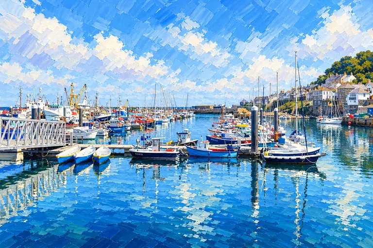
Painting of Padstow harbour on the Camel estuary with boats inside the quay.
Padstow, illustrated for Old Sea Dogs Guides. · Artwork supplied by Old Sea Dogs

Old Sea Dogs Guides

Padstow

On the north Cornish coast, Padstow sits up the Camel estuary behind the Doom Bar — a proper harbour town with quay berths, Rock opposite, and a berthing master who prefers to hear from you before you commit to the approach.

Harbour · West Country

Welcome to Padstow

On the north Cornish coast, Padstow sits up the Camel estuary behind the Doom Bar — a proper harbour town with quay berths, Rock opposite, and a berthing master who prefers to hear from you before you commit to the approach. This is not a short hop from the south-coast chain; treat it as its own north-coast story.

Harbour authorityPadstow Harbour Commissioners
Harbour officePadstow PL28 8AQ
Telephone01841 532239
Email[email protected]
VHFChannel 12
OfficeMon–Fri 09:00–17:00 plus 2 hours either side of HW; Jul–Aug weekends also 09:00–13:00
Prior notice preferred (email) with length and draftPrior notice preferred (email) with length and draft
Floodgatevessels up to ~9.5 m breadth (10 m opening)
Quay dues 2026 (inc facilities/water), per metre / night1–6 nights £2.60; 7–20 £2.20; 21+ £1.95; max visitor stay 1 month
Fuelred/white diesel by arrangement; petrol by prior arrangement with Berthing Master
Arrivals from outside UKNational Yachtline 0300 123 2012

Setting & Character

Padstow harbour and town on the Camel, with Rock across the water and holiday moorings (Red Brick pontoon, Port Arthur, Rock) in season. Inner harbour use is at the Berthing Master’s discretion. Tourism and fishing share the quays — follow local directions.

Arrival by Sea

The Camel approach including the Doom Bar needs a current chart, the harbour’s own passage guidance / navigation materials, and a working plan timed with the tide. Email or call ahead with length and draft; call Channel 12 on approach. This guide gives no bar depths or “safe windows” — use official tables and harbour advice. Orientation only.

Choosing a Berth

The berthing master allocates quay space. Holiday moorings (April–October) at Red Brick, Port Arthur and Rock are bookable products with their own fees — see the 2026 Schedule and holiday-moorings pages. Expect drying or restricted access on some estuary moorings; Red Brick is cited as floating about 2½ hours after low water.

Fuel & Facilities

Diesel from the fuel berth after arranging with the Berthing Master (or leave cans at the office bunker). Petrol by prior arrangement. Shore power, water, Wi-Fi, showers/toilets/laundry (fob + tokens). Gas bottles available.

Tides

Use the free official tide tables linked below — this guide does not copy tide heights.

Padstow Harbour also posts forecast links on its visitor page.

Old Sea Dogs View

The north-coast Camel pin — Padstow for the skipper who has rounded Land’s End or come down from the Bristol Channel, not a footnote on the Fowey–Falmouth run.

Skipper's Notes

Quick notes before arrival.

  • Email draft and length before you commit to the bar.
  • Ch 12 on approach; listen to the berthing master.
  • Floodgate breadth ~9.5 m.
  • Quay dues from the 2026 Schedule — per metre, banded by length of stay.
  • Different coast from Torquay–Newlyn south chain — plan the passage honestly.

Information checked against official sources

The practical information in this Guide was checked against the source records below on 28 October 2026. Operational details can change — confirm with the harbour office before arrival.

  • padstow-harbour.co.uk/visitor-facilities
  • padstow-harbour.co.uk/holiday-moorings
  • padstow-harbour.co.uk/wp-content/uploads/2025/12/2026-Schedule-of-Rates.pdf
  • bbc.co.uk/weather/coast-and-sea/tide-tables/10/545
Conditions

Tide and wind

A quick look at the water around Padstow before you set off. Always check the full forecast and tide tables.

Tide times official tables

Official tide tables via BBC / UKHO and ADMIRALTY EasyTide. Confirm local advice with the harbour office.

BBC Weather tide tables — Padstow

Wind knots

Now
SSE 12, gusts 15
Sat
ESE 6, gusts 10
Sun
NE 11, gusts 16
Mon
ENE 13, gusts 20

Powered by Met Office data. Day figures are for midday. Updated 15:52.

Find your way

Location

This map is provided for general orientation only and must not be used for navigation.

Cruise On

Where the water leads next

West Country

Devon and Cornwall’s south coast — deep river harbours and the long hop west from Portland Bill, from Tor Bay and Dartmouth to Falmouth, Newlyn and Padstow.

Local knowledge

Know this area?

Old Sea Dogs welcomes constructive feedback from local sailors, harbour users and cruising skippers. If you have spotted something that has changed, or have local knowledge that would improve this Guide, we would be pleased to hear from you.

Send Guide feedback